This code is a machine learning script that uses a k-nearest neighbors (KNN) classifier to classify data points into one of three categories: rock formations, bodies of water, and other features. The script first loads some example data and splits it into a training set and a test set. The training set is used to train the KNN classifier, and the test set is used to evaluate the classifier’s performance.
The script then defines a classify_features function, which takes a list of data points and their corresponding predicted labels, and separates them into three lists: rock formations, bodies of water, and other features.
The script then creates a KNN classifier with 4 nearest neighbors, fits it to the training data, and uses it to predict the labels for the test data. It then calls the classify_features function to classify the features in the test data, and prints the number of each type of feature.
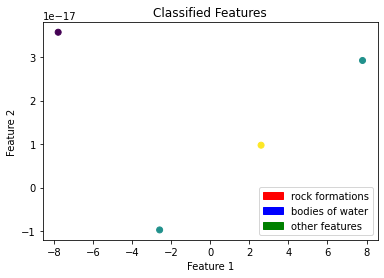
The script also evaluates the classifier’s performance on the test data by calculating the accuracy of the predictions. It then uses a LabelEncoder object to encode the training labels, and reduces the dimensionality of the feature data using principal component analysis (PCA). Finally, it creates a scatter plot of the classified features in the training data, with different colors representing the different classes.
RAMNOT’s Potential Builds:
- Classifying geological features in satellite imagery to identify locations of rock formations and bodies of water.
- Identifying types of land use in aerial photographs, such as forests, agricultural fields, and urban areas.
- Classifying types of objects in images or videos, such as vehicles, pedestrians, and buildings.
import numpy as np
import matplotlib.pyplot as plt
import matplotlib.patches as mpatches
from sklearn.neighbors import KNeighborsClassifier
from sklearn.decomposition import PCA
from sklearn.model_selection import train_test_split
from sklearn.preprocessing import LabelEncoder

def classify_features(data, model, X_test, y_pred):
  # Initialize empty lists to store the classified features
  rock_formations = []
  bodies_of_water = []
  other_features = []

  # Iterate through the data points and predicted labels
  for point, label in zip(data, y_pred):
    # Check the predicted label for the current point
    if label == 'rock formation':
      # Add the point to the list of rock formations
      rock_formations.append(point)
    elif label == 'body of water':
      # Add the point to the list of bodies of water
      bodies_of_water.append(point)
    else:
      # Add the point to the list of other features
      other_features.append(point)

  # Return the lists of classified features
  return rock_formations, bodies_of_water, other_features

def load_data():
  # Define the example data
  data = [
    {'features': [1.0, 2.0, 3.0], 'type': 'rock formation'},
    {'features': [4.0, 5.0, 6.0], 'type': 'body of water'},
    {'features': [7.0, 8.0, 9.0], 'type': 'other'},
    {'features': [10.0, 11.0, 12.0], 'type': 'rock formation'},
    {'features': [13.0, 14.0, 15.0], 'type': 'other'},
    {'features': [16.0, 17.0, 18.0], 'type': 'body of water'},
  ]

  # Return the example data
  return data

# Load the data
data = load_data()

# Extract the feature data and labels from the input data
X = np.array([point['features'] for point in data])
y = np.array([point['type'] for point in data])

# Split the data into a training set and a test set
X_train, X_test, y_train, y_test = train_test_split(X, y, test_size=0.2, random_state=42)

# Create a KNN classifier with 4 nearest neighbors
model = KNeighborsClassifier(n_neighbors=4)

# Fit the classifier to the training data
model.fit(X_train, y_train)

# Use the model to predict the labels for the test data
y_pred = model.predict(X_test)

# Classify the features in the test data using the model and predicted labels
rock_formations, bodies_of_water, other_features = classify_features(X_test, model, X_test, y_pred)

# Print the number of each type of feature
print(f'Number of rock formations: {len(rock_formations)}')
print(f'Number of bodies of water: {len(bodies_of_water)}')
print(f'Number of other features: {len(other_features)}')

# Evaluate the model's performance on the test data
accuracy = model.score(X_test, y_test)
print(f'Model accuracy: {accuracy:.2f}')

# Create a LabelEncoder object
le = LabelEncoder()

# Fit the LabelEncoder object to the training labels
le.fit(y_train)

# Encode the training labels
y_train_encoded = le.transform(y_train)

# Visualize the classified features in the training data

# Reduce the dimensionality of the feature data using PCA
pca = PCA(n_components=2)
X_train_pca = pca.fit_transform(X_train)

# Create a scatter plot of the feature data
plt.scatter(X_train_pca[:, 0], X_train_pca[:, 1], c=y_train_encoded)
plt.xlabel('Feature 1')
plt.ylabel('Feature 2')
plt.title('Classified Features')

# Add a legend to the plot
rock_formations_patch = mpatches.Patch(color='red', label='rock formations')
bodies_of_water_patch = mpatches.Patch(color='blue', label='bodies of water')
other_features_patch = mpatches.Patch(color='green', label='other features')
plt.legend(handles=[rock_formations_patch, bodies_of_water_patch, other_features_patch])